
We understand why some newbie boaters ask, what is a day marker in boating? This question is but one of many that greenhorn sailors have. And it is admirable they want to learn as many navigational markers as possible, as they would with road signs.
Day markers are navigational aids, allowing boaters to maneuver their vessels in the water during the day. We can call them daytime buoys, except they do not need a flashing light.
Table of Contents
What is a Day Marker?
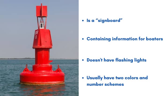
Let us start with a basic definition of a day marker. As the name implies, a day marker buoy is a “signboard” containing information for boaters and other waterway users.
It differs from other navigational markers in that a day marker does not have flashing lights or other illumination mechanisms. After all, these signboards are only effective during the day.
Fundamental day markers come in two colors and number schemes. They “tell” boaters to maneuver their vessels to a section of the waterway and avoid collisions.
So, what are the boating buoys and markers meanings?
Basic Day Markers
Let us look at the two basic day markers boating enthusiasts must learn by heart.
The image below shows the inlet towards an inland waterway. The foreground is the harbor from open waters. The background with the city skyline is the inland waterway.

When we come from the sea and head inland, we go “upstream.” The opposite (from inland to the open waters) is “downstream.” Note that a green square is always on the left or portside going upstream. If we head downstream, our portside will be on the same side as the red square.
Now, let us apply the day marker in this image.
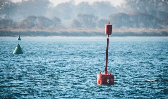
- A green square daymark will always be on our left (port) side if we go upstream (head inland). You will also notice “odd numbers” in the day mark, increasing in “value” as you move further inland.
Let us assume we are done with our business inland and would like to return to open waters. Heading back to sea puts the green day mark to our right (starboard) side, and the odd numbers will decrease in value as we draw closer to the sea.
- On the other hand, a red triangular daymark functions opposite the green signboard. We should navigate our boats to the left of this marker when we head upstream to keep it at our starboard (right) side. Heading downstream requires keeping the marker to the left (port) side.
It also has numbers, albeit in an even scheme. Like the square shaped daymark, the numerical value increases as you head upstream and decreases downstream.
The following illustration should make it easier to differentiate between these two day markers.
How Day Shapes Work
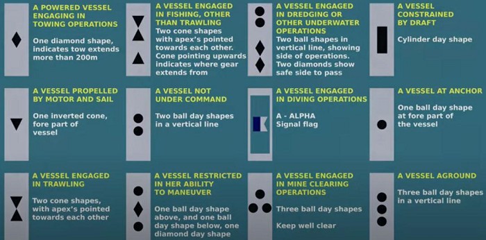
As mentioned, square and triangle day markers inform boaters of their positions in a waterway. Other than these, day shapes are also crucial for communicating with other boats and vessels.
Day shapes allow boaters to identify other vessels (i.e., fishing boats or sailboats). They are available in round (ball), cylinder, cone, and diamond shapes or a combination of these figures.
You might ask what color these geometric figures have. Unlike day markers that feature green or red, day shapes only have black because it remains visible during the day.
A fishing vessel has a day shape comprising two black triangles or cones, one on top of the other in an inverted position.
If you see a single black ball, it means the watercraft is at anchor.
A single diamond day shape indicates ongoing towing operations.
The following image depicts the different day shapes and what they mean.
Other Types of Markers
Day markers are not the only navigational signs boaters must be familiar with. Other markers exist, and aspiring boat owners should learn these as well.
- Navigational Markers – Highways have road signs, and waterways have navigational markers. These signs allow boaters to maneuver their vessels on the “safe” lane, as motorists observe “keep right” on roads.
Examples include lateral markers for identifying safe water sections to navigate. Other markers include cardinal markers, safe water markers, isolated danger markers, special markers, and emergency wreck marking buoys.
- Non-lateral Markers and Others – These navigation aids provide information other than safe water areas to boaters. Most have black lettering and orange markings.
Examples of these markers are control markers (i.e., restrictions and regulations), hazard (danger) markers, information markers (for distance, location, and directions), keep-out (off-limits) markers, and mooring buoys.
FAQs
Is the day mark and night mark on a lighthouse the same?
No, the day and night marks on a lighthouse are not the same. Day marks have high-visibility features, allowing mariners to spot them in broad daylight.
On the other hand, a lighthouse’s night mark is the light beam we all associate with such structures. It can come in different patterns and colors, but the light beam’s purpose remains the same – guide boats and other vessels safely to shore, especially on stormy nights.
Day marks do not need lights to attract a sailor’s attention. The black shapes are enough to convey a message to boaters in the distance during the day.
Day beacon and day marker: what’s the difference?
The principal difference between a day beacon and a day marker lies in their function.
You can consider the beacon a light-less floating structure for mounting a signboard. The day marker is the “signboard” containing information about the sea beacon’s purpose.
It is like the menu at your favorite bistro. The menu board is the “day marker,” while the wooden stand is the “day beacon.”
Conclusion
We hope we provided a satisfactory answer to the question, “what is a day marker in boating?” Day markers are navigational tools, much like road signs on highways, allowing you to steer your craft in the section of the waterway that prevents you from colliding with other boaters.
As a rule, green and square should always be on your left if you are heading inland (upstream) from the open seas. Red and triangle should be on your right (starboard) when going in the same direction.
Boat collisions are nil if boaters adhere to these basic “rules.”

Ten years of enjoying countless trips on boats never made me love them any less! So I am here to put all those experiences into good use for other boaters who want to have a safe and fun trip with their friends and families.